
Overmountain Extreme
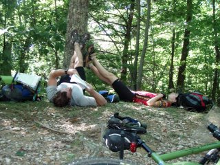
Amazingly this was only my 3rd adventure race this year (CPZ in March, then the Greenway Challenge in May). With so many shorter events filling my schedule, my mind was a bit unfocused, especially considering this year's OME had a 32hr time limit. Luckily, as I started packing up the gear and hit the road, the excitement and adrenaline was building.
The low point was driving 5.5hrs from Chatt to Morganton in the rain Friday afternoon. Alone. (I'm not a fan of driving.) Once there, we had a busy few hours organizing gear, getting it all into the support minivan, and working on maps & our route. I hit the hay around 12:30am....
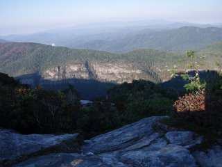
The alarms sounded at 5:15 and we were up shortly thereafter. We were on task and in the car by 6am to head to the start, which was the same as last year: on top of Grandfather Mountain. However this time it looked much different. See for yourself:
2006: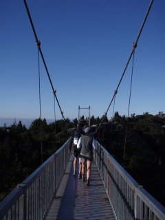
2007: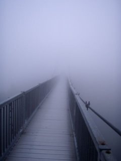
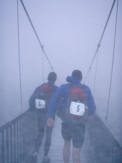
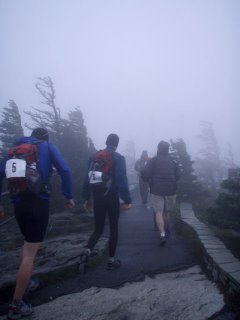
While the temps weren't that cold - mid/upper 50s?!, the fog was thick and wet and winds were sustained at 25-30mph, with gusts up to 50mph. WOW! It was a bit unsettling walking across the mile-high swinging bridge when you couldn't see the other side. We followed the Grandfather, Daniel Boone Scout Trail, Cragway, Nuwati and Asutsi Trails that led us on a breathtaking trek across MacRae Peak (5939') and Calloway Peak (5964'). This year we actually didn't hit the top of MacRae because of the weather - a bit too exposed. There were a few ladder to rock face transitions that had me literally shaking. No room for error. But we all got through safely. Since we can't race through the park, the race clock didn't start until we got to Serenity Farms. That didn't mean that we could lollygag through this section though - even though it was still morning, we were working against the clock. We wanted every minute we could get for the orienteering section later.
 A few hours later, we were running low on water and was able to use a local resident's hose to fill up. He was quite concerned that it was too warm; we didn't want to wait! But it was straight out of the mountain and delicious. From Gingercake, we followed some fabulous singletrack down to 181, which led us to our first encounter with our support crew at Bark House. We kept our transition under 10 minutes, paying special attention to our feet for the section ahead. It was good to see some friends in the chaos (Monica+Chilton, Lauren+Wyatt & Gavin). We left right around 6pm with a snack of boiled potatoes (unfortunately they lost the salt!).
The Mountains to Sea Trail would become our home for nearly the rest of the race. My memories of this trail from last year were not good - yes, it is scenic, but it crosses the creeks constantly which meant wet feet for hours. With all the rain we had Thurs & Fri, we were worried the creeks would be swollen. Somehow though we lucked out and the water was even lower than last year. In fact, it never took us more than 30 sec or so to find rocks to hop across on. We weren't going to waste time looking for a dry route, but if it's just sitting there waiting for us, why get wet?! The goal was to preserve the condition of our feet as long as possible. (And I actually made it through without any blisters, although the soles are bruised/sore). The orienteering section was basically a loop, partially in this area. We nabbed CP8 & 9 in the daylight, then it set on our way to 10. With headlamps on, we continued to run on towards 10 when a rock jumped up and tripped me. I fell hard and this section of trail was not very soft. I had a rock nail the upper side of my right ankle and I writhed in pain for a few minutes. It was hard to shake off that intense bit of impact. I was able to get up and move around more or less ok, although it would slow us down considerably. Hunter & Daniel were great in taking my pack so I'd have less load to carry. (I do feel weird doing that, but they are so strong, it evens things out a bit).
CP 12 was a bit tricky and took us an hour to find, but we did it which meant we cleared the o-section. Yeah!! However, getting back to the transition area would prove to be tricky. The USGS map showed a trail we were on connecting to the M2S trail; the Nat'l Geo Trails Illustrated map showed it not. The alternative route was a longer and on hard paved road, so we took our chances. Well, it didn't work out quite as planned. The trail terminated where we thought it might, so our next plan to bushwack north to the M2S went into action. It worked, but was heinous. Rhodo hell! Possibly worse that CP13 at CPZ.
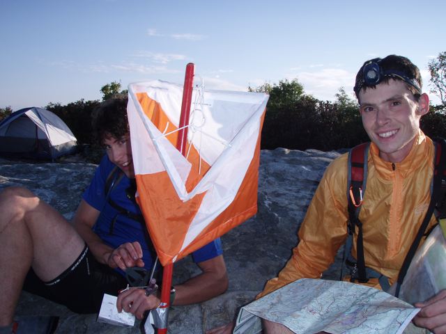
We ended back at the Bark House transition area at 2am... about an hour later than we planned, but an hour earlier than the cutoff. After speedily refueling, we actually set off on our feet again. We had only 1 more CP to get before heading to the summit of Table Rock, but it was quite a treat to get. We came across a few teams on the trail that were doubling back, as they seemed to think the trail ended at a creek. We were a bit disappointed to see this, but pressed on... finding success. We hoped the others wouldn't see where we went - they didn't, and we were able to break away. The trek up to Table Rock was long. By now my ankle was bothering me more and I coudn't run at all. I'm not exactly sure the elevation gain here, but TR sits at 3909' and I know we were below 2000'... so a hefty hike to say the least. We had joked earlier in the race about seeing the sun rise here (we expected to only see stars). The sun came up on our hike up - the camera was stashed though, so no pics of that, but a here are a few from the top.
 Back at the parking lot of TR another bike drop awaited us... it was around 8am I think. Chris (the race director was here) and seemed excited that we had gotten all the points so far - apparently many teams had skipped o-points. We fueled up and put on lots of layers for the descent ahead. The paved road was steep and full of switchbacks. I was getting too much speed for this hour of the day with no sleep, but made it down ok. Once we hit the gravel roads, I felt more at home. We grabbed 1 point on the way to the final transition area. The ride was about 2.5 -3 hrs, then we arrived at Lake James. Time to paddle!
We had the fastest transition recorded - we needed every minute on the lake. A few points had been eliminated to shorten the course, so the opportunity to portage twice saved us a chunk of time. I did have 1 mishap though getting back into the canoe after one portage - I lost my balance and fell right out... and into the water. Luckily I didn't tip the boat over, although I got soaked and knocked the crap out of my calf on the side. The sun was shining strong and warmed me up sufficiently. As we got closer to the inlet where the finish was, we checked our clock. 58 min until the cutoff. There were 2 possible points to get on the lake... 1 being not too far away. We went for it. I timed us from a point across from the inlet, estimating the time to get in. We'd have a certain do or die time to get the point before we'd have to turn around. We paddled hard to the cove, which then seemed to go back forever. We went ashore with 10min available to find the point. We ran to the back point and only needed to spread out for a minute before Hunter saw it. Yeah!! While we wouldn't have enough time to get the last point, we'd finish only missing the one.
We finished with about 20min to spare (compared to last year's stressful 10 min!) Chris and Michelle had a great cookout going and we also celebrated Carol & Neal's birthdays. mmm, brownies!
The final results for coed elite were:
1. Enduraventure
2. Black Dome (both of these teams predictably top place finishers)
3. Charbon's Outfitters --> That's us!! (we also got 3rd place overall, out of 27 teams)
We are all super psyched with our final results. We also won some $ which is nice to help offset the entry fee (and give a little thanks to our awesome support team of Robby & Christy). We are already getting amped for next year's season, which looks to include 3-4 30hr races. We're hoping our solid performance also nets us a more solidified sponsorship from Charbons. (Big thanks to them for supplying us with food and technical t's for this race).
Thankfully, I was able to crash in Asheville with the Curwens and slept for a wonderous 13 hrs. I am feeling pretty ok now, although my feet were still sore when I tried to run last night. My ankle is still a bit swollen, but there's really not pain unless I press the injured area. Now to recover quickly so I can keep the mileage up and be ready for Stumpjump in 2 weeks!
The low point was driving 5.5hrs from Chatt to Morganton in the rain Friday afternoon. Alone. (I'm not a fan of driving.) Once there, we had a busy few hours organizing gear, getting it all into the support minivan, and working on maps & our route. I hit the hay around 12:30am....
The alarms sounded at 5:15 and we were up shortly thereafter. We were on task and in the car by 6am to head to the start, which was the same as last year: on top of Grandfather Mountain. However this time it looked much different. See for yourself:
2006:
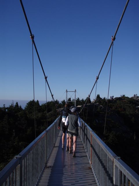
2007:
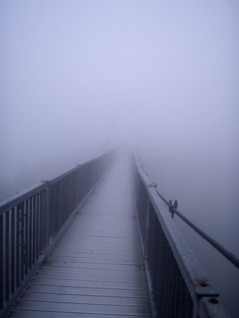
While the temps weren't that cold - mid/upper 50s?!, the fog was thick and wet and winds were sustained at 25-30mph, with gusts up to 50mph. WOW! It was a bit unsettling walking across the mile-high swinging bridge when you couldn't see the other side. We followed the Grandfather, Daniel Boone Scout Trail, Cragway, Nuwati and Asutsi Trails that led us on a breathtaking trek across MacRae Peak (5939') and Calloway Peak (5964'). This year we actually didn't hit the top of MacRae because of the weather - a bit too exposed. There were a few ladder to rock face transitions that had me literally shaking. No room for error. But we all got through safely. Since we can't race through the park, the race clock didn't start until we got to Serenity Farms. That didn't mean that we could lollygag through this section though - even though it was still morning, we were working against the clock. We wanted every minute we could get for the orienteering section later.
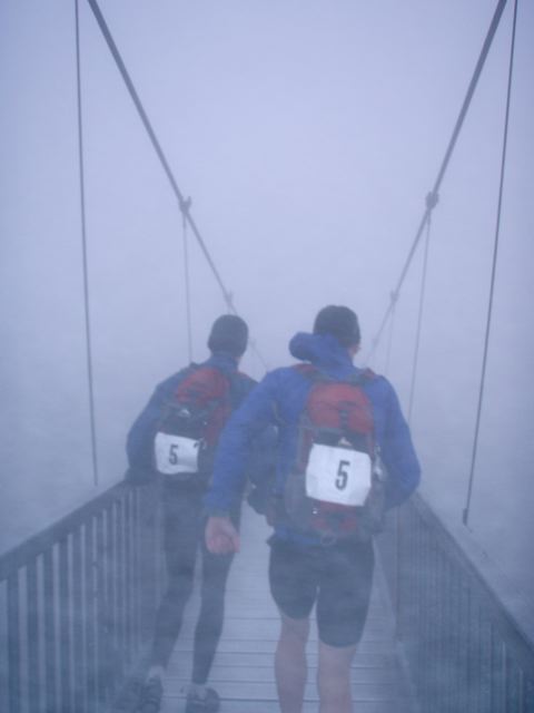

Notice the tree branches blowing sideways in the pics above & below. Yikes!

At Serenity was a bike drop. We transitioned quick (since the support crews weren't there), stashed our trail shoes in our packs, and hit the road. After a quick paved section, we hit some gravel roads that led us to a trail that followed Yancey Ridge, where CP5 was. We actually blew right by it and realized our mistake once we hit a nasty rutted out descent. This should have been an easier point to find and we just didn't track it right. I chalk it up to still getting in our groove :) We then had a few hours on forest service roads, including a stop at Little Lost Cove Cliffs. Here we were allowed to send 1 runner to get the CP, which allowed Daniel and I to rest our feet and study the maps. (Others just relaxed...)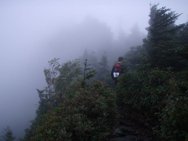
 A few hours later, we were running low on water and was able to use a local resident's hose to fill up. He was quite concerned that it was too warm; we didn't want to wait! But it was straight out of the mountain and delicious. From Gingercake, we followed some fabulous singletrack down to 181, which led us to our first encounter with our support crew at Bark House. We kept our transition under 10 minutes, paying special attention to our feet for the section ahead. It was good to see some friends in the chaos (Monica+Chilton, Lauren+Wyatt & Gavin). We left right around 6pm with a snack of boiled potatoes (unfortunately they lost the salt!).
The Mountains to Sea Trail would become our home for nearly the rest of the race. My memories of this trail from last year were not good - yes, it is scenic, but it crosses the creeks constantly which meant wet feet for hours. With all the rain we had Thurs & Fri, we were worried the creeks would be swollen. Somehow though we lucked out and the water was even lower than last year. In fact, it never took us more than 30 sec or so to find rocks to hop across on. We weren't going to waste time looking for a dry route, but if it's just sitting there waiting for us, why get wet?! The goal was to preserve the condition of our feet as long as possible. (And I actually made it through without any blisters, although the soles are bruised/sore). The orienteering section was basically a loop, partially in this area. We nabbed CP8 & 9 in the daylight, then it set on our way to 10. With headlamps on, we continued to run on towards 10 when a rock jumped up and tripped me. I fell hard and this section of trail was not very soft. I had a rock nail the upper side of my right ankle and I writhed in pain for a few minutes. It was hard to shake off that intense bit of impact. I was able to get up and move around more or less ok, although it would slow us down considerably. Hunter & Daniel were great in taking my pack so I'd have less load to carry. (I do feel weird doing that, but they are so strong, it evens things out a bit).
CP 12 was a bit tricky and took us an hour to find, but we did it which meant we cleared the o-section. Yeah!! However, getting back to the transition area would prove to be tricky. The USGS map showed a trail we were on connecting to the M2S trail; the Nat'l Geo Trails Illustrated map showed it not. The alternative route was a longer and on hard paved road, so we took our chances. Well, it didn't work out quite as planned. The trail terminated where we thought it might, so our next plan to bushwack north to the M2S went into action. It worked, but was heinous. Rhodo hell! Possibly worse that CP13 at CPZ.
We ended back at the Bark House transition area at 2am... about an hour later than we planned, but an hour earlier than the cutoff. After speedily refueling, we actually set off on our feet again. We had only 1 more CP to get before heading to the summit of Table Rock, but it was quite a treat to get. We came across a few teams on the trail that were doubling back, as they seemed to think the trail ended at a creek. We were a bit disappointed to see this, but pressed on... finding success. We hoped the others wouldn't see where we went - they didn't, and we were able to break away. The trek up to Table Rock was long. By now my ankle was bothering me more and I coudn't run at all. I'm not exactly sure the elevation gain here, but TR sits at 3909' and I know we were below 2000'... so a hefty hike to say the least. We had joked earlier in the race about seeing the sun rise here (we expected to only see stars). The sun came up on our hike up - the camera was stashed though, so no pics of that, but a here are a few from the top.

 Back at the parking lot of TR another bike drop awaited us... it was around 8am I think. Chris (the race director was here) and seemed excited that we had gotten all the points so far - apparently many teams had skipped o-points. We fueled up and put on lots of layers for the descent ahead. The paved road was steep and full of switchbacks. I was getting too much speed for this hour of the day with no sleep, but made it down ok. Once we hit the gravel roads, I felt more at home. We grabbed 1 point on the way to the final transition area. The ride was about 2.5 -3 hrs, then we arrived at Lake James. Time to paddle!
We had the fastest transition recorded - we needed every minute on the lake. A few points had been eliminated to shorten the course, so the opportunity to portage twice saved us a chunk of time. I did have 1 mishap though getting back into the canoe after one portage - I lost my balance and fell right out... and into the water. Luckily I didn't tip the boat over, although I got soaked and knocked the crap out of my calf on the side. The sun was shining strong and warmed me up sufficiently. As we got closer to the inlet where the finish was, we checked our clock. 58 min until the cutoff. There were 2 possible points to get on the lake... 1 being not too far away. We went for it. I timed us from a point across from the inlet, estimating the time to get in. We'd have a certain do or die time to get the point before we'd have to turn around. We paddled hard to the cove, which then seemed to go back forever. We went ashore with 10min available to find the point. We ran to the back point and only needed to spread out for a minute before Hunter saw it. Yeah!! While we wouldn't have enough time to get the last point, we'd finish only missing the one.
We finished with about 20min to spare (compared to last year's stressful 10 min!) Chris and Michelle had a great cookout going and we also celebrated Carol & Neal's birthdays. mmm, brownies!
The final results for coed elite were:
1. Enduraventure
2. Black Dome (both of these teams predictably top place finishers)
3. Charbon's Outfitters --> That's us!! (we also got 3rd place overall, out of 27 teams)
We are all super psyched with our final results. We also won some $ which is nice to help offset the entry fee (and give a little thanks to our awesome support team of Robby & Christy). We are already getting amped for next year's season, which looks to include 3-4 30hr races. We're hoping our solid performance also nets us a more solidified sponsorship from Charbons. (Big thanks to them for supplying us with food and technical t's for this race).
Thankfully, I was able to crash in Asheville with the Curwens and slept for a wonderous 13 hrs. I am feeling pretty ok now, although my feet were still sore when I tried to run last night. My ankle is still a bit swollen, but there's really not pain unless I press the injured area. Now to recover quickly so I can keep the mileage up and be ready for Stumpjump in 2 weeks!
Labels: adventure racing, nc, race report
posted by cathi at 8:47 PM
![]()
3 Comments:
Great report!! Congrats, well done!
Well done Cathi! I'm so glad you guys got that CP Count corrected for your hard earned 3rd.
Great report!
Congrats again on a very strong race!
Cheers,
Neal
Post a Comment
<< Home